‘I can’t breathe! Is someone taking a hammer to my head every time my heart beats?’ These are the thoughts that run through my head as we scramble up 4th class rock to the summit of Urus Este. We are at the tallest altitude any of us have been at, closing in on 18,000 feet above sea level. Finally, we stand on what feels like the top of the world, being treated to a 360 degree panorama of the Cordillera Blanca in the Peruvian Andes.

Six of us, four Exit Glacier Guides, headed out from the quaint mountain city of Huaraz two days earlier to set up base camp in the heart of the Ishinca Valley. We hired three burros to help bring our massive amounts of gear and food for six people for five days. On the hike in we did eight miles while gaining 4,000 vertical feet and ended up base camping at 14,500 feet. The picturesque scene was cut by a river running through the flat valley bottom, that had been cut by gouging glaciers hundreds of years ago, with Tocallaraju impeding west face staring at us with at the end of the valley.

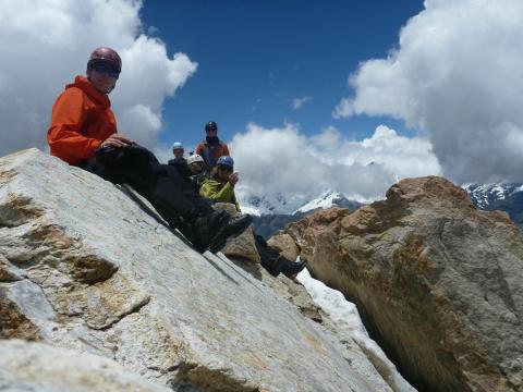
The next day our objective was Urus Este which stood at a stout 17,782 feet. Looking at it from base camp it looked like Mountain Marathons race trail, (classic, steep, hiking trail behind Seward) and we all laughed how it could not be as bad as Mount Marathon. Turned out the first 2,000 vertical feet, until we reached the glacier, were worse than Mountain Marathon, due to carrying mountaineering gear, being just as steep, and a much higher altitude. Once we got to the glacier we roped up and made our way to the col, without much of a problem. At the top of the col we practiced some crevasse rescue scenarios and self arresting in case of crevasse fall. We scrambled the last few hundred feet, all of us feeling the altitude and moving at a snails pace, but we all made it to the summit in just about five hours. We hung out on the summit snapping pictures, snacking on some Peruvian lunch, and just soaking it all in. We glissaded (sliding on snow) down the glacier, cutting our time down for descending. The down trail unfortunately was a total knee buster, being so steep as well carrying a heavy backpack. We made it back to base camp and were all satisfied with our efforts to reach the highest altitude any of us had ever been.
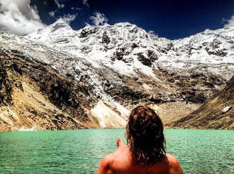
The next day was a day of rest, to relax the sore muscles and catch some zzz’s. Not being content with sitting at base camp all day Olivia, Pyper, Nathan and I decided to head up to the huge moraine at the end of the valley, right under Tocallaraju. We hiked for about an hour and finally made it on top of this massive glacial moraine. Our eyes were treated to a spectacular crystal blue lake with the glacier off Tocallaraju calving into the body of water. There was only one problem, how were we going to get down to the lake? The lake sat 200 feet below the steep and unconsolidated walls of the moraine. Olivia and I were determined to make it down to the lake and go swimming. So while Pyper and Nathan trundled (rolling rocks down hills or mountains) rocks into the lake, Olivia and I set off to find a path to the lake.
After walking to the far side of the moraine we found a doable, albeit sketchy, path down to the lake. After some calculated steps and a little down climbing, we found our way down to the edge of the lake. Soon we were stripping off our clothes for the most beautiful skinny dip of our lives. The water was cold, but was warmer than I was expecting. After Pyper and Nathan spotted us in the lake, they came down and took a refreshing dip in the alpine lake too. Of course, once we went swimming we spotted a trail on the other side and decided to take the easy way out and back down to base camp to eat some food, get some rest, and read ‘The Martian.’
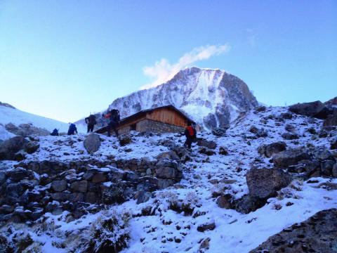
The next morning we decided to make an alpine start and start at 4:30 am, due to our longer and bigger objective of Ishinca. We hiked the long steep trail guided by our headlamps, as well as the stars. We were treated to an amazing sunrise and got to take a breakfast break at the refugio, right below Ishinca. There was snow on the ground at this point as we started scrambling over boulders, fighting off freezing temperatures, and making our way to the glacier. We were all praying for the sun to pop up and start to heat our chilly bones.
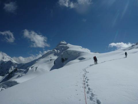
Once we reached the glacier, so did the sun, and soon all those prayers to heat us up were replaced by hoping for shade. Snow reflects almost all the sun rays that hit it, so you can become sun burned very quickly on glaciers. Our two rope teams worked our way up the glacier navigating around crevasses, that would swallow you whole into the darkness. When we reached the col, a few hundred feet from the summit, Olivia and I were feeling the altitude, as well as both battling colds. We made the decision it was our time to turn around, still being at least an hour away from the summit. It is never easy to turn around from a peak when you are so close, but it is always important to remember that the mountain is king and you are just a pawn at the mercy of mother nature. Olivia and I felt good about our decision and headed back to camp, the other four boys reached the summit and got back down in time for Olivia and I to have dinner ready for them.
The next day our two burros showed up with their driver to pick us up and help haul gear out back to the road. On the hike back down, it was a positive time to think back and reflect on our time spent in the mountains. Not only did we learn a lot more about glacier travel and altitude, we experienced what it was like to set out on an expedition. We were able to see how much planning goes into that to feed six people for five days, as well as how much gear we needed to try to climb these peaks. Group dynamics were a very important part of this trip, we were very vocal about our objectives, how we were feeling, and how comfortable we were in given situations. The Ishinca Valley provided a great platform for us to start thinking about longer and further expeditions into the mountains around the world!